Saturday, September 29, 2018

The 2018 Flood VII - Some Progress

20180929_134212
Today, September 29, 2018


In the middle of trying to put a different post together I walked down by the creek out of curiosity to see the level, and I am pleased to see that it has gone down some, but is still a couple feet higher than it should be.  You can see some space beneath the bridge, probably not enough for kayaks or canoes to make it down the creek, but it is certainly improvement.  Either way, all the ducks are swimming in the water - and still don't seem to mind.
20180825_123254
A month ago - August 25, 2018


There's a nifty animation of the lake levels of the last seven days under those blue words.    You can see it's still nowhere near what it should be.

A closer up picture after the break, and a butterfly sign that I don't remember seeing before, oddly.

Friday, September 14, 2018

The 2018 Flood VI - Enough, Already!*

18F yahara-lakes-locks-and-dams
I believe this picture came from here: https://cleanlakesalliance.org/
The lakes had been high all summer so far, see 
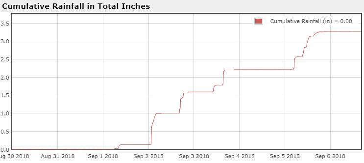
my pic from earlier this year here, then on August 20 western Dane County received the worst of a rainstorm and got 10-15 inches.  Surrounding areas, including us, also got many inches of rain but the double digits got the headlines.  Much of that water flowed to the Wisconsin River and much of it flowed to the Yahara chain of lakes, starting with Lake Mendota.

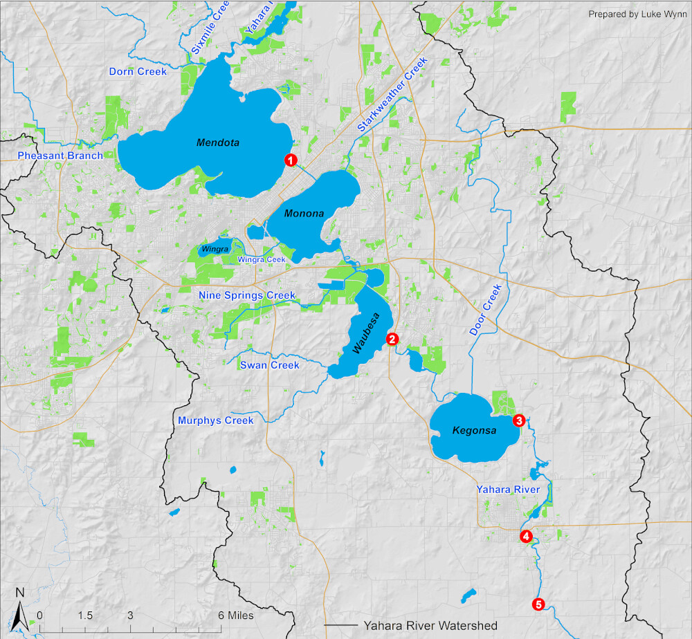
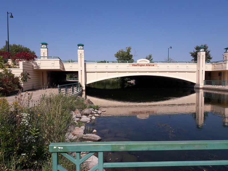
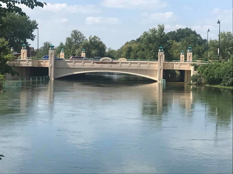
The Tenney Lock and Dam have been tested, but have held admirably.  Lake Mendota drains through that lock and dam (1), into the Yahara River crossing the isthmus to Lake Monona.  If the dam fails, this influx of water is what will flood many low parts of the isthmus and Lake Monona.

Lake Monona has gotten higher than it's ever been. It drains through another branch of the Yahara, one that has had to be weeded in the past because they slow the flow, directly into Lake Waubesa, which then has another lock and dam (2) before draining into Lake Kegonsa which also has a lock and dam (3) that then drains via a lengthy part of the Yahara River and a couple more dams (4,5) until ultimately flowing into the Rock River.  That's the basics, and this is a map to help you visualize it easier if you're not from here.

You can see how it will take time to let all that water flow.  If we were to get any substantial amount of rainfall in a short amount of time, any similar deluge as before, anytime before winter we will be having perhaps much bigger problems.  I should note that it has not rained since the last rain spell I posted of last week, and no real chance is forecast until later next week.  I've been paying attention to the forecast a bit more these days.

There are reasons to keep the lakes high and reasons to lower them to natural levels, and proponents for each have been heard in this renewed debate, despite the problem at hand continuing and expected to continue until at least winter.  I think they should be lowered below the level they've been kept despite the issues for boaters and pier owners.  In time, all would adapt.  Then the next time something like this happens there will be the capacity to hold and handle the flow of water without flooding.  Seems so obvious, why doesn't it just happen? [Insert political crap here.]

20180825_204802
Random green fire pit picture.
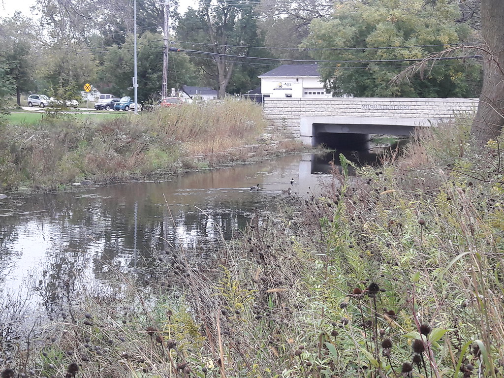
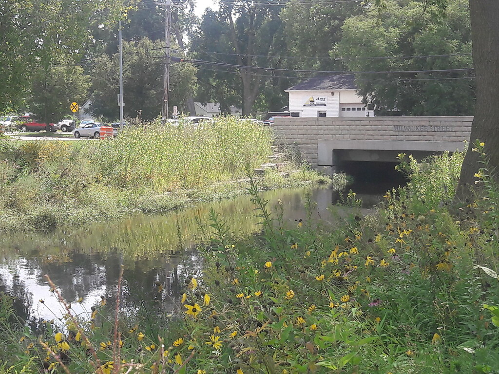
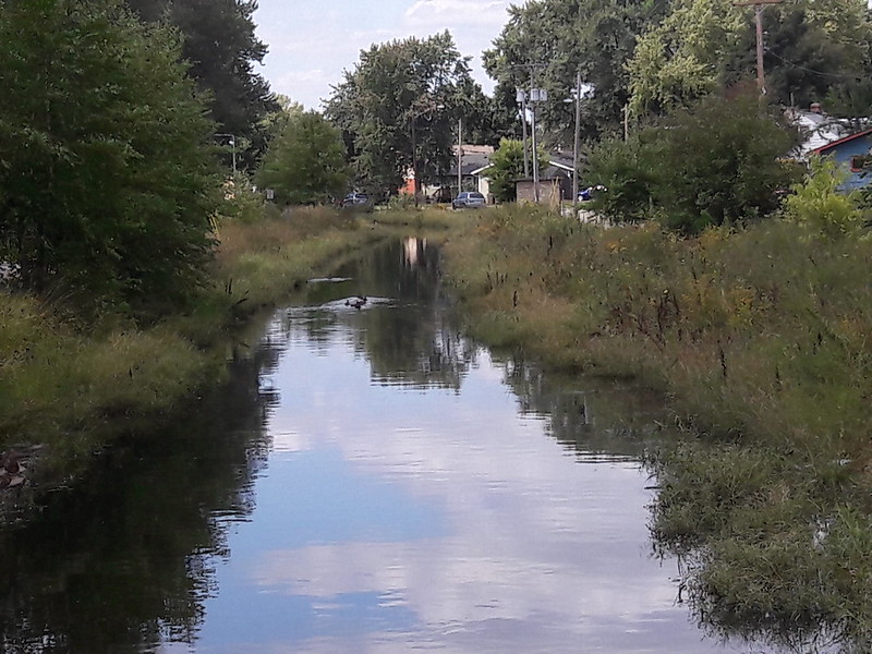
I got out for a bike ride today, just down to the lake and back, less than an hour overall but my joints are feeling it now (and the reason I didn't go yesterday).  I got some good pictures to share, the first few are from a bike ride the other day and the rest are from this morning - except for one picture I stole a screenshot of from goggle maps.  It shows the rocks that should normally be visible on the sides of this stretch of Starkweather Creek.  Since they lakes have been kept overly full the last couple years a cursory search didn't find a similar picture in my albums of the last couple years.  But I have posted pictures of this and these other places in the past so you can seek them out for before and after shots if you wish.

Pictures and comments after the break!

*Originally titled with IV instead of VI - sorry!

Thursday, September 13, 2018

Another Birthday Vacation

DSC00277I had yet another birthday recently, they seem to come faster and faster.  My wife made snacks and we had some people over last Saturday evening to celebrate.  Thanks to all who came over!  I took the week off for my birthday again this year but, once again, I had no big projects planned but a reasonable list of chores I wanted to get done.  And sleep, sleep is very good.  As I type the chore list is mostly complete but we'll just have to see how the rest goes.

Otherwise, I've been out on the bike a couple times and got some more pictures of the swollen creek.  I've not made it all the way to a lake yet, but I do plan on biking to probably Olbrich Park later today or tomorrow.  I know I have pictures of the shoreline from winter to compare to, well, we'll just see what I find.  Lake Monona has been up to 3 feet over it's predetermined maximum, as reflected in the creek.  I'll put another Flood post together in a day or two.

In other happenings, the Packers and Badgers have started playing so there goes much of my time on weekends for the next few months.  My mom broke her foot - sorry ma, I'm not traveling during my vacation but I'm sure Dan is taking very good care of you.  I hope you get well soon.  And I'm still enjoying the fire pit almost every chance I get.  Even just sitting by the fire for an hour or two in the evening is so simple yet lowers the stress of every day life - but you'd better have mosquito repellent!

20180901_152736
Just a dragonfly I spotted recently.

Thursday, September 6, 2018

The 2018 Flood V - Rain Accumulation

The rain has continued this past week, as we watched nervously.  Water levels had been going down a bit until yesterday when we got more rain all day.  Nothing as drastic as what got us in this mess but yesterday was a very wet day, indeed, and on ground that is already water logged.  The good news is that the next several days look dry so hopefully we can get those water levels down a bit more.  I'd like to go down and get a picture of the creek right now but I just mowed the lawn so I already have enough mosquito bites to last me for a while...

Rainfall Capture

Not a lot happening to speak of, otherwise.  We do plan on having people over for a fire pit on Saturday night and I have time off coming up.  Maybe I'll find something else to write about then!

Sunday, September 2, 2018

The 2018 Flood IV - Political Waters

It's been two weeks since the heavy rains of August 20 washed in to flood streets, homes and businesses, and there is no end in sight.  Lake levels were already about a foot higher than their predetermined maximum, now releasing the water down through the lakes and the flooding it will cause is making this a political issue once again.  Meanwhile, we have streets that have been underwater this whole time.  Let's just hope we keep avoiding any heavy rainfalls for a while.  Oh, it also rained another inch last night.

I found a very good website for information on the lakes, dams and water levels for our Yahara chain of lakes, link here.  And I also found the short video below, posted two days ago, of the Tenney Park area.  I'm sure it looks very similar still, especially after last night.


I hope everyone is enjoying their holiday weekend.  I've been taking it pretty easy so far, but I may get out for a bike ride today.  Last night we had a fire before the rains came and cooked pizza and fruit pudgie pies in the coals. They were good but I burnt the first one and they did make quite a mess!

Thursday, August 30, 2018

The 2018 Flood III - Ducks Don't Mind

This picture from a couple hours ago is looking back upstream from the bridge in the picture from the last post.  Water levels are the same, but the ducks don't seem to mind.  Normally you would see big rocks on the sides of this part of Starkweather Creek, still very underwater.  Thankfully, recent rains have not not been enough to very much worsen the issue.

20180830_142419

The city posted a map of properties to notify because of the danger of flooding.  On our street there's surprisingly just one, a few houses down and across the street on the end, by the creek.  For the water to make it up the hill to our house there would have to be some catastrophic happenings, thankfully for us - and not very likely.  I thought of stopping by the lake on my way home today so I could show the difference compared to earlier photos, but didn't due to traffic.  I'll see if I get a chance this upcoming holiday weekend.

Saturday, August 25, 2018

The 2018 Flood II

I went down by the creek today to see how it looked, not quite as full as yesterday and there is a slight flow to it again today.  Yesterday it was fuller and stagnant, which tells me it was at lake level.  Still, it's going to take a while for the waters to go down, and we have a chance for rain and thunderstorms the next few days yet.  You can see here how the creek may be too full for canoes and kayaks to make it under the bridges very easily.

20180825_123254
Across the city, many home and business owners are trying to dry out and assess the damage.  As far as I know there is still flooded areas and roads on the isthmus and all across western Dane County.  I have not heard anything about the Tenney Lock and Dam, so that's probably a good thing.  Reports can be found online pretty easily, starting with here and here.

We've had no water in the basement since the big rainstorm earlier in the week.  When we get water in the basement it just runs toward the drain, but there are a few areas where it pools so we squeegee it towards the drain and turn on the dehumidifier.  It is now dry again and I don't think we'll get any more unless it rains again soon.

Terry sent us some pics of the marina where she keeps her boat that I'll put after the break.  I don't think she'll mind me posting them - thanks Terry!  The water's edge is normally on the other side of the open structure you'll see, and now is right up to the buildings.

Thursday, August 23, 2018

The 2018 Flood

We've had rain recently.  The other night we had 10-13 inches in the western part of Dane County.  Madison is in the middle of the county and it was literally down the center, and we are just east of that line.  We had several inches of rain here too, by the way, even had to bring up the rugs in the basement, but no major issues.  In other parts of the city that amount of water had an immediate - and in many places an ongoing - effect, and in the days after the water is running it's course, down the chain of lakes, starting with Mendota.

I don't want to write a lot, I'm tired.  But I haven't posted much and this is very significant to us.  Below you will see pictures stolen from the neighborhood farcebook group page along with pictures I took during a bike ride last year.  The Yahara/East Washington bridge below, a few of the Tenney Lock after the break, and a last tired thought at the end.

20170914_114340
My picture, last September.


2018WasingtonBridge
Recent farcebook picture